|
|
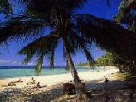
Located in the territory of Pha Ngan island, that is Pha Ngan island forest of national forest reservation, there are waterfall, forest and the animal is quite, then can develop the place of travel in future. The Royal Forest Department has surveyed; Pha Ngan island forest of national forest reservation, Namtok Than Sadet forest, Khao Lat Kaeo forest, Khao Khai forest, Khao Ta Luang forest, Khao Hin Nok forest, Laem Pho-Laem Kata Khwa forest and Khao Fai Mai forest. Nowadays, in the processing has proclaim it to be a national park and using call of the name "Than Sadet - Ko Phangan National Park" , covers a total area of approximately 65.93 sq. km. The landscape is high mountains, highest peak of the hills is Ra hill of 627 meters higher from the average sea level. The mountain forest is quite consists many island such as Pha Ngan island, Tae Nok island, Tae Nai island, Ma island, Tung Ku islans, Tung Ka island, Wao islands and Hin Bai island, about 30 kilometers to the north form the Pha Ngan island. Generlly the overlapping mountains and the plain stand by the valley and any of the bay area around the island. Than Sadet Waterfall Than Sadet Bay Than Prapat Waterfall Than Prawet Waterfall Phang Waterfall Khao Lar Viewpoint The highest hill of Pha Ngan island, around 627 meters from the sea level. There is viewpoint overlooking the beautiful view below clearly around the island, 10 kilometers far from the head office of the national park. Laoyu, Wao Yai and Niat Islands - |