|
|
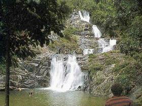
Khao Lampi Hat Thai Mueang National Park covers area of 72 square kilometers. Lam Pee Mountain -Tai Muang Beach National Park is the eastern area of Andaman coast, consisting of two parts, the first part is Tai Muang beach and the second is Lam Pee mountain. The Tai Muang is located on the coast of Andaman sea, the end of beach is the Kham Bay Peninsula (Giant Face mountain) , the eastern part of this area has a big brackish water canal getting fresh water from Lam Pee mountain which still has the fertile primary rainforest. Lam Pee comprises of a lot of mountains which laid from north to south with getting higher about 40-100 meters above the average sea level. The highest mountain is Kanim mountain, located in the northern part area with height of 622 meters from the average sea level. Thai Mueang Beach Thai Mueang Beach, is protected primarily as a nesting site for 2 species of sea turtles the Leatherback and the Olive Ridley. The females come ashore to lay their eggs between November and April. Unfortunately sea turtles are now very rare, and only a few come ashore. Sea Turtle Far from the national park office only 800 meters, be one part of Had Thai Muang. Lam Pee Waterfall The inland section of the park, covers a waterfall and surrounding forested hills, it is located about 14 km from the park headquarters. To get there: turn left at the junction in Thai Mueang and continue for about 10 km until you see a blue sign for the waterfall. Turn right and continue up the track for about 2 km. The waterfall is a local attraction and has a pool suitable for swimming at its base. Meals and drinks can be purchased at the several small stalls located near the waterfall. Ton Phri Waterfall 50 meters height, the lower level be the big pond suitable for swimming. Origin of this waterfall is Khao Ton Ban Sai which has a fertile forest. |