|
|
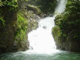
Nam Tok Sai Khao National Park covers Amphur Kok Pho, Pattanee province, Amphur Sabayoy Songkla province, Amphur Yaha and Muang Yala Province, with an area of about 110 km2. The topography is mountainous in San Kala Kiri mountain ous range, covers with fertile moist evergreen forests, it is headwater of many rivers flow to Tepa River. The park is located on a complex Sangalakiri mountain range with its summit of Bang Chun mountain. Most of the area slopes down westward from the mountain as a hill and plain. Soil characteristic is clay mixed with sand and stone characteristic is limestone and granite stone. Sai Khao Waterfall flows from high cliff of about 30m, high and about 700m, long there are many trees close of the river and make it' shady and beautiful. Nam Tok Phong Phong flows from 7 levels. It's very pleasant because of trees of several kinds along the river. Nam Tok Phra Mai Phai It is a small-size waterfall which water flows from cliff 10 meters in height through hillocks to granite stone ground then runs widely down to the stream which will eventually be Tepa River. There is one Buddha Image named Phra Weru-wun which were built unanimously by Hnode villagers located near by the waterfall. This waterfall is located 12 km far from Sai Kaw Waterfall and can be reached by taking the Sai Kaw-Sbar Yoy route, there is a crossroad heading to waterfall at Ban Hnode village junction. Nam Tok A-run Wa-rin A-run Wa-rin Waterfall composes of 6 floors, the top floor is 30 meters in height where is the water flows in steps through hillocks downward to a reservoir. This beautiful waterfall located in Koke Po District is under developing to be one of tourist place of Pattani Province. San Kala Kiri Mountain Trekking Trail is the most interest nature trail. The occurrence of plants and wildlife of several species. |