|
|
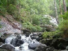
Formerly, Nam Tok Ngao National Park was called Klong Prao National Park, located in Amphur La-un, Muang, Ranong province; and Amphur Sawee, Thung Tago, Lung Suan, Pa To, Choomporn province. At 668 km2, the park's general geography is rugged mountain range. And it has valuable trees forest and headwaters, suit to set a national park. The general topographic composition of the park are mountainous regions, which includes Khao Daen, Khao Huai Siat, Khao Nom Sao, and can be seen stretching from the northern to southern areas of the land. Khao Nom Sao is not only the highest mountain in the park, peaking at a height of 1,089m above sea level; it also provides a very important watershed for the provinces of Ranong and Chumphon. Ngao Waterfall located near the Headquarters, you can follow Phetchkasem road for 13 kilometers then turn left at the intersection that opposite Khao Ya and follow the road for 1 kilometer. The waterfall has water drops over the high and steep cliff that you can see it even you are far away. Khlong Phrao Waterfall a beautiful waterfall that has water flows all year. These are 5 levels, the third level is 36 meters high. Separate from Lang Suan-Thung Tago road for 14 kilometers, you will reach the fall. Bang Rin Waterfall located in Moo 2, Tambol Bang Rin, Amphur Muang Ranong. Turn left at the intersection next to Bang Rin bridge along Muang Din Khao road parallel Klong Bang Rin for 3 kilometers. The steep waterfall is wellknown among Ranong people. Cheaw Klai Waterfall situated in valley of Tambol Bang Phra Nua, Amphur La Un, Ranong. It has water flow all year. |