Mu Ko Ra Ko Phra Thong National Park

|
|
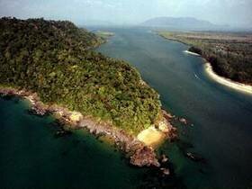
The Mu Ko Ra Ko Phra Thong National Park has been created in March 2000. In general, the area, located the west of Phangnga Province, consists of sinking seashore and productive mud-beaches on estuaries of many long rivers. The area is influenced by ebb and high tide of the sea. There are high mountains and islands lie north and south such as, Ra Island with the mountains about 235 meters above sea level, Phra Island with plain area, Kho Khao Island with high mountain about 310 meters above sea level, and many small islands such as Pling Island, Tachai Island and Bosai Island which has the highest mountain about 450 meters above sea level. Ra Island It is a very steep island, most of the land will be closed to the shore. Visitors can walk and study the nature with long and wide beach in the north and west of the island. It is suited for swimming, sunbathing, or seeing the sunset. It can be reach only 60 minutes. Phra Thong Island There is wide land with no mountains. On the east of the island is forest can be able to drive there. It is an area for wide lives such as deer and boar. There are many kinds of activities such as camping and cycling. Besides the long and wide beach from north to south is also good for studying animals because there are 60 deers. It is good for visitors and can be reach by boat for 50 minutes. Kho Khao Island It is the land and mountain in Kuburi and Takuapah district. It is very beautiful and has long beach along the shore. Currently, there are coconut fields and villages. It can be reach within 30 minutes. Pling Island and Phota Island It is closed to each other. There are many coral reefs on the west but not so wide. Visitors can walk or seeing birds. Because of the different of the plants, this area is good for many activities such and sailing the kayak, or cycling. It is also good for eco-tourist. |