|
|
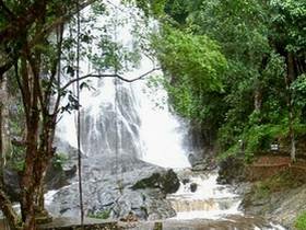
Lam Nam Kraburi National Park covers the area of approximately 160 sq.km, consisting of Kraburi River, parting Thailand and Myanmar, small islands scattering along Kraburi River and Mangrove Forest by the Kraburi River banks and the National Reserved Forest area consisting of Khlong Set Kuat Forest, Khao Hin Chang Forest, Khao Sam Lam Forest, La-Un Forest Ratchakut Forest and Khlong Lam Liang-La-Un National Forest. Tropical Rain Forests can be found around Khlong Set Kuat Forest, Khao Hin Chang Forest, Khao Takian Forest and La-Un Forest /Ratchakut Forest National Forests and the most distinctive vegetation found only in this area is Khun Mai with large, straight trunk and cashew nut like seeds. Such vegetation is found around Punyaban Falls, La-Un Forest/Ratchakut Forest National Reserved Forest and Mangrove Forest. Tham Yi Pun Situated on Ko Khwang and is 500 meters in depth. Formerly a Japanese Military Base during World War II. Kra Buri River The Kra Buri River, the border between Thailand and Myanmar, is 60 km along from source to mouth, and 6 km wide. The river banks are natural and there are a number of islnad groups. The whole boundary area of Thailand and Myanmar has healthy mangrove forests, and has a high potential for river tourism, such as rafting and boat trips. In the future when the Lam Nam Kra Buri National Park boundary has been officially declared, cooperation between Thailand and Myanmar in organising tourism for the Kraburi River area can be enhanced. From the Isthmus of Thailand, following the river down to Ko Song or Victoria Point Island in Myanmar, arises a National Park between countries, which has the highest potential in tourism and conservation. This will lead to good relations and further opportunities for cooperation between Thailand and Myanmar. Islands of the Kra Buri River Consisting of 6 islands namely Siat Island, Khwang Island, Yao Island, Khon Island, Pling Island, and Nok Plao Island which are situated right in the middle of the river with the most perfect mangrove forest and absolutely no population whatsoever. Punyaban Waterfall Punyaban Waterfall is an all year round falls by Petchkasem Road Km.598 with the average number of 100,000 tourists visiting per year. The originating point of this fall is La Un/Ratchakut National Forest. Sed Kuad Peninsular Sed Kuad Peninsular is an area of healthy mangrove forest, the tip of which stands out into thr Kraburi River. It is located in the National Park Headquarters area, covering an area of approximately 3.2 sq.km. Khao Hin Chang View Point Situated in the area of Khao Hin Chang and is the point where Kraburi River, its islands and the mangrove forest, along with the Myanmar scenery can be viewed widely and clearly. Bo Namron Had Yai A total of 3 hot springs are located in Mu 2, Tambon Bang Phra Nua, La Un District, Ranong Province, and around the Had Yai Ranger Station. Ton Pak Waterfall 3km far from Ranger Station 1 (Hat Yai). Located Moo 2 Tambon Bang Phar Nuen Amphur La-oon Ranong province. It's has 4 levels. |