|
|
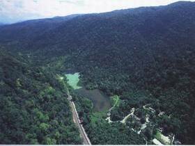
Thaleban National Park was declared as the 20th National Park in Thailand in October 1980. The park encompasses a total area of 196km2. Thaleban is approximately 1,000 km south of Bangkok, in the province of Satun. The park covers the mountainous border area between Satun province, Thailand and Perlis state, Malaysia. Most of the area is mountainous with lush forest. Existing lime stone hills which are constantly washed by the underground water results in large cavity or even a large cave such as Toan Din Cave, Pah Deo Cave and Pooyoo Cave. Moreover, the dissolved underground lime stone burrow also result in the sea swamps in the area. The highest mountain in this area is Chin mountain, 756 meters from the average sea water level. Ton Din Cave Ton Din Cave is 1.5 kilometres away from the National Park Headquarters. The depth of the cave is approximately 700 metres with stalactites, stalagmites and small creek within. Many types of fresh water fish and mining equipment left over from the World War 2 can also be found. Lot Poo You Cave Lot Poo You is a cave similar to a cave in Ao Phangnga National Park. Located in the southern part of the national park near Khao Kayang Mountain and surrounded with mangrove forest. Within the cave, there are stalactites and stalagmites. Transportation to Lot Poo You Cave has to be via boat at Tammalang Pier, approximately 9 kilometres away from Satun and 58 kilometres from the National Park Headquarters. Wangpra Grassland Large grass fields located in between the mountains in the western part of the National Park where a number of wildlife such as mouse deers, porcupines red jungle fowls and Asian tapirs inhabit. From the National Park Headquarters to this grassland, it is 8 kilometres to the North then take left road for another 10 kilometres. Ya Roy Waterfall This waterfall with a series of nive falls is located 6.7km north of headquaters. It is signposted from the road and the falls are reached along a track after about 700m. The bottom pools can be busy but the highest fall is the best for swimming. A unit of the park protection force resides here. Thale Ban Swamps A large swamps in the middle of the valley, against Khao Chin mountain range and Wangpra mountain. The total area of this swamp is approximately 0.2 sq.km. Freshwater fish and shellfish are very common. Bakong trees are also very concentrated around the swamps where frogs inhabit. Asin Tapirs can occasionally be seen drinking from the swamp. Nature Trails Two Nature's Attraction Trekking Routes -One is 1.3 kilometres and the other is 600 metres. One Trekking Route - Thaleban National Park to Namtok Yaroi Ranger Station. The distance is 14 kilometres. Ton Piew Waterfall The most beautiful waterfall in the park with a good year round water supply. The falls are 10 km north of headquaters, signposted from the road a track leads a further 3km to the waterfalls. These falls are much quieter and usually a secluded pool can be found even on a busy day. |