|
|
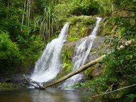
Khao Sok National Park has a general topographic composition of Limestone Mountains and possesses the scattered peaks of Ka Lo Mountain whose form resembles those of towers. The highest peak to reside in the park measures at 961 m above sea level. The area in which the park is located contains highly acidic, sandy soil that is easily eroded during rainstorms. Khao Sok National Park is a virgin forest where various types of plant life can be found. This includes a number of very rare and sacred tree species such as the Neobalanocarpus heimil. A few other plants that can be seen in this park include the following: Genus Hoper, Chisocheton and Anisoptera etc., as well as small bushes such as the Rafflesia kerrii, palm, rattan, betel palm, and various types of bamboo. Wing Hin Waterfall is an attractive waterfall on Klong Sok River. Huge boulders litter the stream about 20 m. from the base of the falls. You can use these boulders as stepping stones to cross the river. The attractive crossing point is known locally as 'Bang Wing Hin' or 'Narrow Running Rocks'. The waterfall is about 2.5 km. from the Headquarter. Tang Nam Two majestic cliffs that can be seen facing each other; it can be located on the deep end of the Sok canal and serves as the habitat for a variety of fish species. Tang Nam is just 6 kilometers away from the headquarters and requires 3.2 kilometer walk and 3.2 kilometer from the Bang Wing Hin Waterfall. Ton Kloi Waterfall A beautiful one-level waterfall on the Sok canal and has a consistent water stream flowing all year round. It is located approximately 7 kilometers from the headquarters, or 1 kilometers away from the Tang Nam. Tharn Sawan Waterfall is a beautiful waterfall along a tributary of the Sok River. The forest torest trail leading here is difficult and requires wading along the stream bed for the last 1 km. This is slippery and can be dangerous during rainy season when the warter is at full force. Sip Et Chan Waterfall water pours over the 11-stepped staircase of rocks that makes up this attractive waterfall. The large pool at the bottom is great for swimming - you will need cooling down after walking the 4km from the headquarters. Mai Yai Waterfall This is the only waterfall that can be reached by car. It is located next to the Suratthani-Takuapa road (also known as 113rd km), or 5.5 kilometers away from the headquarters. The waterfall, although is only one-level high, measures an approximate 30 meters in height. The best time to visit this waterfall is during the rainy season. Khang Khao Cave thousands of bats live in this large chambered cave. You can hear them twittering and squeaking and will smell their distinctive aroma as you explore the cave with its beautiful stalactites and stalagmites. Please do not shine torches up onto the bats, as this will disturb them, as will loud noise. Ratchaprapa Dam this large man-made dam was built to provide hydro-electricity for Surat Thani and other towns. Over 100 islands dot this massive lake, most of the clustered in the narrowest part of the lake, an area known as 'Chong Kaeb Khao Ka Loh'. The dam is a 65 Km. drive from Headquarters. Local people run boat trips and trekking around the Dam as part of an eco-tourism project. Nam Ta-lu Cave It's located at Ranger Station 4 near by Ratcha Prapa dam's reservoir. It can be accessed by boat only. Taking boat at Ratcha Prapa port, it takes only 15 minutes to go to the start walking point, then walk further about 2 km long, you will reach the cave eventually. The cave's entrance is 30 meters width and inside is wide with a beautiful scenery stalactites and eroded stones. Interestingly, there is a stream runs through the cave along the 500 meters length. |