|
|
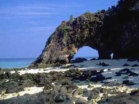
The 51 islands of the park archipelago lie in the Andaman Sea from 20-70 km.. off the extreme southwest coast of peninsular Thailand. Tarutao, the largest of the islands, is 26.5 km. long and 11 km. wide. The topography is mostly mountainous (highest point 708 m.) with a few broad plains and valleys. Semi-evergreen rain-forest blankets about 60 percent of the island, and pure mangrove swamps are found in several areas. Long sandy beaches lie along the western coast from Pante Bay to Makham Bay, and at Talo Udang Bay in the south. Ko Adang (Adang Island) In the past, it's the home of pirates who robbed the ships. The beach is beautiful with white sand. There're coral reef surrounded that's good place for scuba diving. Ranger Station 5 (Laem Son) is located 40 km. far from headquarters. Pha Chado Viewpoint (Chado Cliff Viewpoint) Located in Adang Island. In the past, it's the place where pirates made an observation for other ships, goods ship. Now it's good place for seeing the beautiful sight of the sea. You'll see pine forests and white sand beach of Adang Island. You also see Ko Lepe from here. It takes you 30 minutes. Ao Phante Malaka It's where Tarutao National Park 's headquars located. White sand beach is good for taking a walk, swimming ,picnic and camping. Pha Toe-Boo Viewpoint (Cliff trail) A popular sunset photo-op, good view of distant islands, rippling sea, thick forested hills and soaring birds of prey. The trail to this 114 meter cliff begins directly being the library & office; between garage and official guest houses. The route passes limestone, mixed deciduous forest and scrub forest. Time: 15-20 minutes. Take the shortcut straight down the cliff with breathtaking ladders; trail to shortcut begins beneath the platform viewpoint. Charakae Cave (Crocodile Cave) Mouth of cave lies at the end of one of the Pante Malacca Canal's many mangrove-lined channels. The cave is filled with brackish water and extends several kilometers. Only once has the cave been followed to its end opening near Jak Bay; by 3 rangers in a rubber raft, in the days when crocodiles were still a resident of the salt-water swamp. The boat trip is scenic, with close-ups of the mangrove ecosystem, various birds, and lucky visitors will catch a glimpse of a spectacled langur pausing still in a tree. To arrange a boat trip, contact the information booth. Try to share the cost with other visitors. At present, a walkway extends only a short way into the cave. Bring flashlights and/or candles. Ao Jak (Jak Bay) It's a small bay connected to PhanTe Malaka Bay. It's white sand beach which's good for taking a walk and picnic. Ao Molae (Molae Bay) A small cove just south of Jak Bay; with a coconut plantation, uncompleted park buildings and a villger's bamboo house. The path/road that leads here passes through a tiny mangrove swamp area at the very south end of Jak Bay. At high tide, you will have to wade through the water approximately 50 meters. If continuing to Son Bay, be aware that the road disappears in the sand. To be sure of finding it again, keep to the left of the villager's house and walk straight. Ao Son (Son Bay) 2.5 hours, 8 km. from headquarters, along the beach to Jak Bay at low tide or at high tide, via the road. The trail takes you through a coconut plantation at Molae Bay, and onwards through the forest, to Son Bay. At Son Bay, look out for Pythons resting on a branch overhanging the river, rest on the white sand beach, or walk to Lu Du (1.5 hours) or Lo Po (2.5 hours) Waterfalls, for a freshwater dip. You can camp at Son Bay. Lu Du Waterfall Lu Du River provides the water for the Ranger base at the north end of the beach, whilst Lo Po meanders through dense mangrove forests to the south. Follow either river upstream and you will find cool, refreshing pools and pretty waterfalls. Look out for coloured arrow trail markers, and stone cairns for stream crossings. Lo Po Waterfall Lo Po Waterfall trail starts about 1 1/2 kilometres south down the beach. It was originally made in April 1990 by Peace Corps volunteers, under the supervision of the then Head Ranger of Son Bay, the longest serving Ranger of Tarutao, Mr. Niwon. The trail passes through Beach Forest and Evergreen Rainforest. Look for the coloured arrow trail markers and stone cairns for stream crossings. The waterfall is more spectacular in the rainy season, but the pool is enough to bathe in and the trail is fun to walk. Absorb the atmosphere of silent rock faces and thick lianas draping to the ground. Distance from Ranger Base: 6 km. Time: 2 1/2 hours. Ao Makham (Makham Bay) It's the place where Ranger Station 3 (Ao Makham) is located here, at the bottom of the freshwater stream. In the non-monsoon season, subsistence fishermen (mostly Muslim) keep temporary shelters here. As of yet, no trail exists between Sone Bay and Makham Bay. Ao Lue See (Lue See Bay) It's a small bay with a cave and good for snorkelling diving. Ko Klang and Ko Khai (Klang and Khai Island) These small islands are about halfway between Tarutao and Adang-Rawi Islands. Ko Klang was a former ranger station, but fresh water and snakes were a problem. Ko Khai is the small idyllic island with the famous stone arch, blinding white sand and clear aqua sea. The word "Khai" means egg in Thai, indicating a large sea turtle nesting site in the past. There is some damaged coral around Ko Khai, and colorful fish, but spiky sea urchins seem to dominate. Ko Hin Ngam (Hin Ngam Island) It's a small island with round black rocks beach. The rocks will reflect beautiful light when the sun shines. Each of the rocks here was cursed by Tarutao's god who will punish everyone who steals the rock from the island. Ko Yang (Yang Island) Yang Island located near Ko Hin Ngam to the north. It's surrounded by coral reefs such as staghorn coral, leaf coral, It's a good place for snorkelling diving. The beach is beautiful with a crystal clear blue sea. There are plenty of beautiful fish live around the coral reef. Ko Chabang (Chabang Island) Chabang Island located between Ko Adang and Rawie Island. It's surrounded by pink soft coral, lavender soft coral, red soft coral with the arrange shade of colors. There're phylum porifera, sea whip, sea anemone, feather star and beautiful fish which live in the coral reef. It's the good place for both snorkelling and scuba diving. Ko Rawi (Rawi Island) Rawi Island is a place where there's white sand beach. It's quiet place suits for pitching tents. It's the place where Ranger Station 6 (Hat Sai Khao) and Ranger Station 7 (Talo Palean) is located. Ko Lipe (Lipe Island) There is a village with a school and shops, and private tourist bungalows are available for rent. National Park staffs are unable to book these in advance. The advantage of staying at Lipe Island is a amazingly diverse coral reef within swimming distance; at Gra Island, the tiny isle with the lone conconut tree. One can also observe the sea gypsy village life. There are more restaurant options and stores here than at Adang Island. Lipe Island is a small flat island dominated by coconut plantations. Pattaya Bay on the other side of the island offers an isolated swimming and sunbathing area. But beware of sunbathing alone when there are fishing boats moored nearby; incidents have been reported in the past. Ko Dong (Dong Island) It's the farest island of all. The remarkable thing in this island is range of rocks, which lie on each other in a beautiful but strange style. There's place for both scuba and deep diving where you can enjoy the beautiful sight of under water world. |