Mu Ko Phayam National Park
|
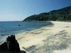
Preparing area to award as National Park Mu Ko Payam includes a section of the plain beach at Andaman Sea and can divided into 3 groups as follow
Beaches area , which stretches into the sea and covered with thick swamp forest. There're many large canals lying across such as Ngao canal, La Ong canal, Rat Chakut canal, La-un canal, Bang Chak canal, etc.
The area which lying near the coastal : such as Bang Chak island, Yio island, Sai Dam (black sand) island, Son (pine) island and other islands. Each of the islands covered with thick swamp forest in the east while there's beach and bay in the west. The virgin forest 's also the main part of the island.
The area which lying far from the coastal : such as Chang (elephant) island, Thalu island, Ta Khrut island, Mo (pot) island, Pring island, Rai island, Fai Mai (fire) island which lying spread from north to south along with the beach line. Each of the islands covered with virgin forest while the coral reef is surrounding the islands.
Mangrove forest
There's mangrove forest near the coast where the forest's still untouched by human. There're varieties of dwelling system which's good for natural activities and do mangrove research because this is the place where small leaf mangrove is still remain in Thailand. It located in the north of Yio Island.
Hat Sai Deang
Hat Sai Daeng (red sand) is on Ko Ta Wua Dam where the sand is red like the color of brick because of the pile up of varieties of seashell for a long time ago. Hat Sai Daeng includes a sight of beautiful forest and hillocks.
Hat Sai Dam
Po Bay located in the south of Ko Sai Dam(black sand). It's a quite curve beach with a beautiful sight of beach and mangrove forest.
Hat Hin Ngam
Hat Hin Ngam can be found around Ko Fai Mai (fire) . It's the only place where you can find rock beach among the entire island in National Park because it's the place where varieties of rounded was piled up for a long time. It will reflect the light when there's wave.
|