|
|
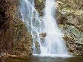
Namtok Sipo National Park consists of complicated mountain range and productive rainforest. It is a habitat of many kinds of wild animals, and a beautifully natural place of Narathiwat Province. Lying from north to south, the area consists of high complicated mountains, some of which are uplands which are best for growing upland corps. The highest mountain in the area is Maetae Mountain. The north part is in contact with Lalo Sub-district, Rueso District, Narathiwat Province. The south part is in contact with Dusongyo Sub-district, Chana District, Narathiwat Province. The east part is in contact with Chaloem Sub-district, Kalisa Sub-district, Ra Ngae District, Narathiwat Province. The west part is in contact with Tamayung Sub-district, Si Banphot Sub-district, Choengkhiri Sub-district, Si Sakhon District, Narathiwat Province. The forest of the Park on the west bank of Saibuti River is productive rainforest almost covered with threes. On the top of the mountain range lays the all-year-round green forest derives valuable plants such as Malacca Teak, Yang, and many different kind of iron wood. And the rainforest in the Park makes it be the habitat for many kinds of wild animals, for example; mammal such as monkey, langue, barking deer, mouse deer, deer, porcupine, loris, civet cat, and giant squirrel; bird such as hornbill, hill myna, hawk; and common koel, and many kinds of aquatic life. Namtok Sipo Being a big and beautiful waterfall, Namtok Sipo consists of seven levels. The seventh level is the most beautiful because it has a 30-meter-high cliff full of water falling down onto lower pond so that people can enjoy playing water. The waterfall is the source of water used for growing tasty Longgong (meliaceae). The first level, not far from the Namtok Sipo National Park headquarters, has a large pond caused by a dam, and also has a sidewalk from the office up to many levels of the waterfall. Namtok Aisuedo Consisting of seven levels with 200-300 meters high, the wonderful waterfall locates in Village No 1, Si Banphot Sub-district, Si Sakhon District, Narathiwat Province. Namtok Yakabongo Causing by two streams met each other and fallen from 60-meter-high cliff, the waterfall is the most beautiful especially in the rainy season. |