|
|
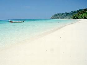
Establised in 1990, according to the order of Mr. Chaun Leekpai, Prime Minister and Wild Animal and Plant Foundation of Thailand. It includes Ko Rok, Ko Mai Ngam Tai, Ko Ta La Beng, Ko Lanta Yai, Ko Ngai, Ko Tu Kon Lima, Ko Rok Nok, Ko Rok Nai, Ko Hin Dang and nearby islands of Ko Klang district, Ko Lanta Noi district and Ko Lanta Yai sub district, Amphoe Ko Lanta, Krabi province. It is the 62th national park of Thailand which covers area of 134 square kilometers or 83,750 rais. Over all geographical feature is the complexity of mountains and rather deep slope. The plain area would be found only in a beach area in the southern part. Most of area here is more than 35 percent slope, except only the middle part of island where a slope is more than 50 percent. The height of this are is range from 100 meters above sea level to a heigth of 488 meters at the peak of mountain. Ko Rok Nok & Ko Rok Nai Including Ko Rok Nok and Ko Rok Nai. The colorful beachs are located on the eastern part of Ko Rok Nai and the south-eastern of Ko Rok Nok. Coral is the most tourist attraction here. Laem Thong Located in the northern part of Ko Rok Nai. Cliff side looks like a group of small islands. If you look at the opposite beach, you can see the sunset between them. Ko Rok Nok View Point Located ih the back side of Ko Rok Nok. Here, it has white sand beach which you can walk to the other side of the island which shaped like a horse shoe. Two side of this gulf is the height black cliff. Ao Man Sai This is the other part of beach of Koh Rok Nok which has a long beach with a mixed species of beach forest, mud-beach forest and monsoon forest. The sea in this area is very shallow. If you walk into this forest, you will find a big tree so called "Ton Sai" ( Ficus sp.) which has a lot of roots droped from its branchs, let it looks like a big curtain with 5-6 meters width. Ao San Chao This beach located next ot the Ko Rok Nai. In this area, there is the under ground water which drain onto the ground in the summer season which become the reservoir for all year round usage. Ko Hin Ha Luk Ko Hin Ha Luk or Ko Ha or Ko Tuk Narima, It is the group ot five islands, the big one has a field on the top. One of them looks like a sail-boat and has a big tunnel which a sea water can pass through. On the top of this island, you can see a beautiful view. This area has a shallow coral. Ko Ngai There is a long and quiet beach which suitable for seeing a shallow coral. It's far away from the national park office about 18 kilometers. Ko Ta La Beng This limestone island consists of a small beach which would be flood with sea water whenever it has a high tide. It has a cave near a sea side which is a habitat of swallow birds. Laem Tanod Ko Lanta Yai It has a beautiful beach at the back side of main island and a group of small islands. The headquaters of national park of Ko Lanta is located here. The end of Ko Lanta Yai is looked like the triangular shape which one tip protudes into the sea and has prominent sugar palms on it while the other side is a height cliff covered with the monsoon forest. |