|
|
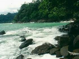
Khao Lak -Lam Ru Natitonal Park covers 125 square km. This national park has been establish in 1991. General geograhy consists of many moutains such as Lak mountain, Lam Ru mountain, Sang Tong mountain, Mai Kaeo mountain and Prai Bang Toa mountain. The highest peak is about 1,077 meters about the sea level which is the origin of the important rivers of Phang Nga province, namely Ta Kua Pa river and Phang Nga river and also consisting of many small canals and streams. The Khao Lak - Lam Ru national park office is located in the shore area nearby sea covering the rock beach ecological system, sand beach and coral ecological system. The park has a number of waterfalls the most visited being Lam Ru waterfall. This waterfall is located about 30km from the park headquarters. Another waterfall is only 10km from headquaters; it is situated at the end of a rough track, so an offroad vehicle is recommended. The waterfall is a short 10 minute walk from the end of the track. This waterfall has been used as a forest retreat for Buddhist monks, a shrine and remains of their shelter are still visible nearby. The waterfall is a single drop of about 10m with a pool at the base which is good for swimming, this waterfall is best visited in the dry season as in the monsoon the quantity of water makes bathing dangerous. A Forest trail leads up into the interior of the park from here. Lek Beach It's the white sand beach which is very quiet and able to swim, dive and see coral. You can go to this beach by walking from the national park headquarters about 1.5 kilometers through forest and passing on the line of sea shore. Ton Chong Fa Waterfall The source of this waterfall is Bang Nian canal and becomes a medium waterfall including 5 large levels which be classified as the beautiful waterfall. Lam Phrao Waterfall and Hin Lat Waterfall The origin of Lam Phrao Waterfall is Plai Bang To canal, consist of 3 levels while the Hin Lat Waterfall has only 2 levels. Khao Lak Sea Shore Khao Lak Sea Shore and beach is very beautiful and consists of shallow coral. You can see this lovely natural view from the view point on the top of the cliff. This area is not safe for swimming. Lam Ru Yai Canal It's a big canal consisting of many small canals, each of them becomes a small beautiful waterfall. It uses to be the water supply for Thai Mueang district. Lam Ru Waterfall Being the medium size waterfall, it has 5 levels and water all year long. |