Most of the area consists of not much complicated mountain range such as Khaokaw Mountain Range, Tabard Mountain, Tachoat Mountain and Kampang Mountain. At the ridge of the mountains, 100-836 meters above sea level, is the border of Thai and Cambodia. The highest peak is Khaotabath Mountain Peak 836 meters above sea levels. The area is the source of canals such as Klong louk, Klong kaew, Klong hinpleang, Klong lue, Klong kajai, Klong malagor etc. Water in all of these canals flows to Klong sator and to the sea. The area consists of rain forest which is the source of rivers and has many kinds of plants such as small shrubbery and 25-60-meter tree. The valuable trees in this area are Dipterocarpaceae, Marlabar ironwood, Sterculiaceae, Meliaceae, Lagerstromeae etc. And shrubberies found normally are ginger, galangal, rattan, palmae, bamboo, fishtail palm, and areca palm etc.
The surveyed area is naturally productive forest so that makes this area has a number of animals, for example, a great number of leeches in many wet places show that the area still has a great number of wildlife too.
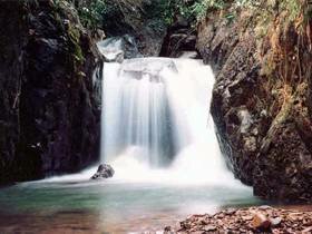
Khlong Kaeo Waterfall
Khlong Kaeo Waterfall is a medium-size and seven-level waterfall, located in Village No 2, Boploi sub-district, Borai district, Trat Province. It is a naturally beautiful waterfall which has very clear water stream with schools of fish diving below. These are suitable for people who love nature. At the fourth level of the waterfall has a great floor of rock, called "Larn Hin Te", which is a very nice place to enjoy the scenery of Borai district.
Khlong Thai Waterfall
Locate in Village No 3, Nonthi sub-district, Borai District, Trat province.
Lanhindat Waterfall
Locating in Village No 1, Nongbon sub-district, Borai district, Trat province, Lanhindat Waterfall is a small waterfall which has water flow all the year round. This area is appropriate for hiker, and has toilets ready in service.