Kaeng Krachan National Park
|
Kaeng Krachan is located on the eastern slope of the Tenasserim Mountain Range at the border of Myanmar. It occupies the western half of Phetchaburi Province (Kaeng Krachan and Nong Ya Plong districts) and a portion of northern Prachuap Khiri Khan province (Hua Hin District).
Most of the park is covered in deep, steep forest. The forest is rich and complex, with hanging lianas, ferns and orchids, and an abundance of fruiting trees and vines. The forest of kaeng Krachan is unusually diverse because of its location at the juncture of continental Asia and the Malaysian Peninsula. Continental species such as oaks, chestnuts, and maples are found here, as are peninsula palms and fruiting trees.
The area, about 45 squares kilometers, consists of both ground and water in reservoir. The vastly forest upper the Kang Kra Jan Dam is on complicated mountain ranges which the highest peak is 1,200 meters above sea level and approximately high 500 meter above sea level. Most of the mountains are Granite Mountain, few are Limestone Mountains, and many are full of fluoride. And also most of the area is covered by rain forest so that is the source of Phet Buri River and Pran Buri River.
Caves
There are many caves in Sam Yod Mountain Range. Wiman Cave, for example, has very beautiful stalagmite and stalactite and also some remains of ancient people.
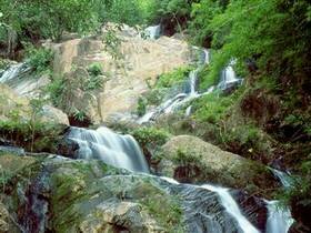
Chollanat Waterfall
Chollanat Waterfall is a 3-level waterfall which is the highest, about 150-200 meters, in Kang Kra Jan National Park, located near Par La U Waterfall, Hua Hin District, Prachuap Khiri Khun Province.
Enjoying the beautiful river and Thor Thip Waterfall
It is a route intended for being a traveling route in the national park about 34.5 kilometers. Traveler can enjoy sceneries of mountains, sea of fog, evergreen forest, and many kinds of wild animals.
Hanuman Plain or Khao Pakarang (corol mountain)
It is a rocky mountain looked very strange like coral. The area has a lot of monkeys, langurs and gibbons. And the area is also a good view point for enjoying scenery.
Hin Lard Waterfall
Hin Lard Waterfall is a 5-level cascade, which has water fall all the year round, near Tor Thip Waterfall and Tharn Thip Waterfall.
Hua Pa Ngao Waterfall
On the south of this area, close to Huy Sat Yai the project under the patronage of His Majesty the King, there are many big and small waterfalls, which can be divided into four groups, in Nong Plub Sub-district, Hua Hin District, Prajuab Kiri Khun Province. There is also a convenient way to visit.
Huy Par Lao Waterfall
It is a 7-level cascade near Par Pa U Waterfall, Hua Hin District, Prachuap Khiri Khun Province.
Kaeng Krachan Reservoir
The reservoir of Thailand covers an area of 46.5 square kilometers and has a capacity of 710 million cubic meters. It was created by the construction of the earth dam which blocked the Phetchaburi River. The largest island in the lake is approximately 0.75 square kilometers. Many tourists enjoy hiring a boat for sightseeing around the lake, observing village life from the water, and visiting the islands.
Kang Kao Cave
There are many beautiful folds and tunnels in the cave. Traveler can also travel to enjoy the scenery of the mountain and forest.
Kradang Nga Waterfall
Kradang Nga Waterfall locates in the north of Kang Kra Jan National Park, the area of Nong Ya Plong District. It is a 3-level waterfall.
Mae Laliang Waterfall
This 3 levels waterfall is located 5 kilometers west of the roadside campground at Km 27. It is recommended for day hiking and camping.
Pala-u Waterfall
This popular waterfall has 16 levels, and is located in Amphur Hua Hin, Prachuab Kiri Khan province, in the southern part of the national park. Water flows throughout the year. Two other waterfalls, Huai Palao Falls and Chonlanath Falls, are located near the ranger station at Pala-u Chonlanath is the tallest waterfall in Kaeng Krachan National Park.
Panoen Thung Mountain
at 1,207m above sea level, this is the second highest peak in the park. On the mountain top, grassland and evergreen forest make a good camping spot, with cool temperatures year-round. The view from the top includes a beautiful panorama of green forest, mountains, sunrises and sunsets, and the "sea of fog" formed when mists fill the valleys in the early morning. Mineral licks in the grassland attract large mammals. A 6-kilometer trail begins at Km 27 for a strenuous hike.
Pha Nam Yod Cliff
The cliff can be clearly seen from the bank of Phet Buri River by people traveling on water by raft. It is a high and erected cliff which always has water drip onto the river, and has more water flow especially in rainy season, causing evergreen moss over its face.
Phet Buri River
There are very beautiful sceneries on both sides of the rivers. Traveler can go by raft to enjoy the productive forest and many kinds of wild animal.
Pranburi Waterfall
This 3 levels waterfall is located on the upper Pranburi River, in the valley just south of the steep hill-climb at Km18-23 on the Khao Panoen Thung Road. It can be visited on one-day hike.
Tharnthip and Hinlad Waterfall
These two waterfalls cascade through deep forest all year long. They are located on a tributary of the Pherchaburi River about 5 kilometers upstream of the Thortip confluence, and may be visited as part of 3 or 4 day loop trek along with Thortip Waterfall.
Thorthip Waterfall:
at this 9 levels waterfall deep in the forest, water flows all year round. The waterfall is reached by a steep 4 kilometers trail from the end of the Nam Tok Thorthip Road, 35 kilometers from the edge of the park and 55 kilometers from the headquarters. A campground has been built nearby at the confluence with the Phetburi River.
Wiman Cave
Beautiful stalactites and stalagmites are found in this cool cave. Evidence of ancient inhabitants-ceramics and stone axes-has been found in this cave near the Huay Kangpla waterfall.
|