Phu Hin Rong Kla National Park has an area of 307 square kilometers. It lies in Dansai disteict of Loei province and Nakhon Thai district of Phitsanulok province. Phu Hin Rong Kla is blessed with natural beauty and historical significance. Unfortunately, the fighting there during communist years did priceless damage to the forest. The geologied features landscape and natural beauty in the area have been restored and protected after the communist insurgents loss.
From 1968 to 1972, the mountains of Phu Hin Rong Kla were the major strongholds for the communists, who were threatening the political stability of the nation. In 1982, government forces began the battle in Phu Khang, and attempt to drive out the insurgents. Forces from the First, Second and Third Army of the Regional Army Commend joined together with the Aviation Divison, Special Force center, the Royal Navy, the Royal Air Force, and Civilian Thai Forces in trying vanquish the communists. The government forces were unsuccessful, primarily because of the unforgiving terrain, set high up in the mountains in mostly dense forest.
The Army changed its battle plan after initial setbacks and eventually rousted the communests. The Third Army and various military forces, the police and Civilian Forces and the Civilian-Police Military 33, (P.T.T.33) led by Major Pairot Chanurai defeated the communists wihtout bloodshed. Villagers in the area. Mostly Hmong, who had initially sided with the communists, eventually decided to abandon their allies. The communists were forced to give up their territory. After that, the P.T.T.33 began to develop the area by building a road. The paperwork was also begun to establish a national park. The Third Army and the Royal Forest Department begun the discussion about turning the area to be park.
In February 1983, the National Park Division sent officials to survey the area and concluded that it had fantastic natural beauty, served as an important watershed, and had many historical points such as Lan Hin Taek and Lan Hin Pum. It was deemed on agreement that Phu Hin Rong Kla had ability to be national park. The Royal Forest Department proposed the park and the assembly on March 15, 1983. A decree made areas of Nakhon Thai district in Phitsanulok as well as Dansai district of Loei into national park in 1984. Phu Hin Rong Kla officially became Thailand's 48th national park.
The general topography of the park is steeply mountainous. The northern part of the park in Chaiburi Dstrict borders Laos. The Southern part of the park runs into Phetchabun Province. The mountain range includes the peaks of Phu Phangma, Phu Lomlo, Phu Hin Rong Kla and Phu Man Khao, the tallest in the park at 1,820 meters above sea level. The second tallest is Phu Lomlo at 1,664 meters. The park is the headwaters of many streams, including Huai Mueat Don, and Huai Luang Yai.
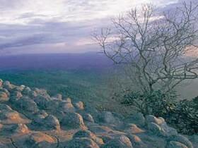
Lan Hin Pum
About four kilometers from the park headquarters, near the cliffs, is a field of nodulated stone, Whose lumps are roughly equal in size. It is believed that this formation resulted from physical and chemical erosion. Patients from the hospital suffering from fever would used the area as a rest spot, as a cool breeze blows over the area almost continuously.
Lan Hin Taek
300 meters to the west of the Thai army headquarters (Than Phatcharin) is Lan Hin Taek (Broken Rock Field). Along the path, growing in rock crevices are various plant species, including mosses, ferns and ground orchids. The crevices, arranged in rough rows. Seem to have come from the earth splitting. Peering into their depths can be eerie. Some crevices are narrow enough to jump across; other are wider. From several can be hard loud echoing of running water. The crevices were perhaps important to the communists, as they could have been used for hiding.
Man Daeng Waterfall
It is about 22 Kilometers away from park headquaters, on the way to go for Lom Sak district. This waterfall has up to 32 levels in total and its headwaters arises from Phu Man Khao peak. This takes 3.5 km walk on the trial paralleled with dense forest. Park staff is necessary required to guide visitors for trailing.
Pha Chuthong Cliff or Flang-Ple Cliff
A steep cliff overlooking a magnificent view of the vally to the west. The communists used this cliff to fly their red flag after each victory over the government forces.
Phalat and Tatfa Waterfalls
At the foot of Phu Hin Rong Kla, Phalat is about two kilometers from Huai Namsai. At the base of the falls is a small hydro-electric generator. If you climb three or four kilometers further up the mountain, you will reach Tatfa Waterfall (also known as Dan Kosong Waterfall), an impressive, towering waterfall.
Romklao-Pharadon Waterfall
Romklao-Pharadon Waterfall is about five kilometers from park the headquarters. As you approach the road to the School of Military Politics, the path to the waterfall is on the left and leads about one kilometer off the road to the waterfall. The forest in this area is in good condition, with many large trees. A side trail leads to Pharadon Waterfall, which is downstream of Romklao Waterfall.
Siphatcharin Waterfall
This medium-sized waterfall is about 600 meters off the road, near Huai Namsai village. The trail leads past some fields of Hmong villagers and into a small valley. It then runs with a stream about 150 meters until reaching the falls. Sipatcharin Waterfall is the most accessible waterfall in the park.