Mae-ngao National Park is situated in Mae Hong Son Province, covering an approximate area of 257,650 rai. The National Park is a beautiful natural sightseeing spot and being the source of many rivers flowing into Salaween River.
The topography of the National Park consist of high mountains, which are the sources of many rivers flowing westwards into Salawin River of Myanmar.The waterway system of the National Park is similar to pattern of the tree diagram, consisting of a large river and its branches. Major rivers and gullies, include:
Mae-ngao River Mae-ngao River is the longest and most important river, passing the areas of the National Park for approximately 42 kilometers long, starting from Ban Sob-khong, flowing northwards to Sob-ngao and meeting Mae-yuam River. Mae-ngao River is the provincial boundary, whereas, the western part of the River is Tha Song-yang District of Tak Province, and the eastern part thereof is Sob-mei District of Mae Hong Son Province. The River is approximately 10-12 meters wide and the water is so clear that it is called Mae-ngao River. In the rainy season, the River, which is used as a water transport route to Sob-mei District by tribesmen, has the very rapid water. Many gullies within the National Park, which flow into Mae-ngao River, include Huai Mae Loh-noi, Huai Mae-bang, Huai Mae Lela-kro, Huai Oloh-gro, Huai Kong-oum, etc.
Mae-yuam River Mae-yuam River flows from Khun-yuam District, passing Mae La-noi District and meeting Mae-ngao River at Ban Sob-ngao, Sub-District Mae-sod of Sob-mei District and meeting Mei District at Ban Sob-yuam, Sub-District Mae Sam-laeb and flowing into Salaween River. The River is approximately 215 kilometers long, and being considered as one of the major rivers of Mae Hong Son Province.The River flows southwards, passing the western area of the National Park for approximately 14 kilometers long.
Rid River The River is situated in the north of the National Park, flowing westwards to Sub-District Kong-koi, Sub-District Mae-suad, and meeting Mae-yuam River in the south of Ban Mae-suad.
Huai Mae-khong The Gully flows from Om-koi District and meets Mae-ngao River at Ban Sob-khong.
Burana-prapa Waterfall
The Waterfall is situated near the route of Mae-sod Mae Sa-riang at Ban Mae-wei Boki. And you may travel on foot for approximately 500 meters.
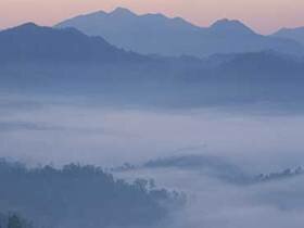
Doi Pui
The Sightseeing Spot is located at the altitude of 1,000 meters above the medium sea level. And you can see a distant view of the areas in Om-koi District. Particularly in winter, you can see the beautiful sea of fogs; and the weather is cold and breezy.
Doi Pui Luang
At present, there is no vehicle route to the mountain ridge of Doi Pui-luang, except a jungle route, which takes you 2 days for round trip on foot. The Sightseeing Spot is located at the altitude of 1,600-1,700 meters above the medium sea level. The mountain ridges extend to the area of Om-koi District. In winter, you can view the beautiful sea of fogs; and the weather is cold and breezy. The Sightseeing Spot is suitable for tourists who enjoy jungle travelling and camping.
Mae La-or Waterfall
The Waterfall, originating from Mae La-or Gully, is situated near the route of Mae-sod - Mae Sa-riang and flowing into Mae-ngao River. And you may travel on foot for approximately 400 meters.
Mae Wa-luang Waterfall
The Waterfall is a beautiful multi-step waterfall, situated at Ban Mae Wa-luang of Tah Song-yang District, Tak Province. The Waterfall originated from Mae-wa Gully. You may start the travelling by walking from the National Park's office and on the way to the Waterfall, you can view different kinds of wild plants and strange birds.
Mae-jae Waterfall
The Waterfall is situated at Baan Mae La-kee. And you may travel on foot from the side of Mae-sod - Mae Sa-riang Road for approximately 1 kilometer to the site of the Waterfall. The Waterfall originated from Mae La-kee Gully, flowing into Mae-ngao River.
Natural Teak Forest
There are a lot of rare, natural teak forests and strange lower plants found in the areas of the National Park, which is suitable for jungle tours and natural study.
Ngao River
Sai Nam-ngao is a major river within the area of the National Park, in which water is so clear that it is called Mae-ngao River. The River is tortuous along islets and reefs. In the rainy season, the River has the very rapid water. In the dry season, the River is suitable for rafting and sightseeing since there are a lot of trees and flowering plants such as Lagerstroemia speciosa (Inthanin) on both sides of the River.
Oloh-gro Waterfall
The Waterfall is a large and beautiful waterfall with the flowing water throughout the year, situated in the north of Ban Om-loh (near Mae-ngao River). The Waterfall is about 150 meters high, originating from Oloh-gro Gully. There are virgin forests in the area of the Waterfall but no vehicle route is built to access the Waterfall, except a jungle route, which takes you 2 nights and 3 days for round trip on foot (on the way to the Waterfall, you need to stay overnight at the Karen's village, then, travel on foot for approximately 3 hours to the Waterfall; and on the way back home, you need to stay overnight at the Karen's village for another night).
Tham Mae Om-ki
The Cave is situated near Ban Mae Ob-ki. There are beautiful stalagmites and stalactites inside the Cave. And there are some streams of water flowing out of the Cave's entrance.
Tham Pla
The topography of Pla caves are similar to those of Tham (cave ) Pla-Pha Sua National Park. Pla caves is situated in the north of Ban Om-loh (near Mae-ngao River). At present, it is the location of Ban Sob Mae-pae. There are a good deal of fish inhabiting in the cave since villagers believe that they are sacred fish and whoever eat the fish will face the disaster.