Khlong Wang Chao National Park
|
On the 7th December B.E. 2531 (1988), the Minister of Agriculture and cooperative and parties have surveyed the condition of conservation, forest Klong Wang Chao, Klong Suan Mak forests. They found the fertile and densely teak forest and others features. They would like to conserve the forest, thus, Klong Wang Chao National Park was gazetted on the 29th Augus B.E. 2533, (1990) with 747 km 2 .
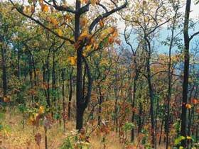
Most of the area consists of complicated mountains lying along the north and south. They are one part of Thong Jai Road moutain range and there is a plain area in their middle part which looks like two pan basins covering 2000 - 5000 rais. The important mountain ranges are Yen mountain, Tao Dam mountain, Tad Roop Kai mountain, Mee mountain, Doi Bang Sung, Bang Cha Le mountain, etc. Yen mountain located in the western park is the highest peak with tall about 1,898 meters above the average sea level while the height of this area is about 300 - 2,000 meters above sea level.
Hot Well
Hot Well warm water erupts from the earth face with average temperature of 50-70 degrees Celsius. The area covers 1 rai or 0.0016 km2. Located about 1.5 kilometers from Tao Dam. It is also a habitat of wild pig, barking deer and asmber deer.
Khao Kradan
Khoa Kradan is a cliff area of Khao Tao Dum Mountain, located nearby Tao Dum Waterfall. It's so called Khao Kradran (Mountain Board) because its shape looks like a cliff that built from many wood boards overlaid up till 300 meter height.
Khao Panang Cave
Khao Panang Cave a big cave situates near Klong Suan Mak. The 100 meters long cave comprises with stalactite and stalagmite.
Klong Pong Waterfall
It is a slate waterfall consists of four levels. The top level is 100 meters high. Travelers have to walk about 20 kilometers through semi-evergreen forest.
Klong Samo Kluay Waterfall
Klong Samo Kluay Waterfall a middle size waterfall with 5 levels. The first levels drops 40 meters. Water reflected topaz colour, which is beautiful and mysterious. Located 800 meters from Head Quater.
Klong Wang Chao Waterfall
Klong Wang Chao Waterfall is a middle waterfall in Klong Wang Chao. The water drops over 60 meters high cliff to the pool below. Situated on km. 29 of Wang Chao-Lo Ko road, 29 kilometers from Phaholyothin road.
Nan Kao Roo
Nan Kao Roo it is named by hill tribe. Because Lo Ko stream, which passes this area, flows through the mountain to the another slope.
Pak Klong Nakiri
Pak Klong Nakiri a natural rapid has water flow over granite. It is a meeting point of Klong Wang Chao and Klong Nara Kiri.
Pha Klom
Pha Klom it looks like a big pencil diving the earth face. The steeply cliff is reached by trekking from Nam Kao Roo for 3 kilometers.
Tao Dam Waterfall
Tao Dam Waterfall a 3 levels waterfall, each has 200 meters high. The third level straight down 270 meters that made it great and wonderful.
Tham ThepPhaNom
Tham ThepPhaNom are huge size caves with many bats living. The nature generally like Tham Khao PaNang.
|