|
Nam Nao one of Thailand most beautiful Park covers an area within Amphur Mueang Lom Sak and Lom Kow in Phetchabun provice and Amphur Kornsan within Chaiyaphum province. The park Headquarters is in an unusual and fascinating landscape: deciduous forest dominated by tall pine trees.
The area is mountainous and its forests provide an important watershed for the surrounding districts. The Park covers in total an area of about 966 square Kilometres. The unusual and fascinating Park designated a National Park on the 4th May 1972.
Nam Nao covers the border between northeastern and northern Thailand. Its particularly part of the Phetchabun mountainous range running through Chaiyaphum and Phetchabun provinces. Phu Phajit mountain is the tallest in the Park and topography comprises evergreen forests and streams. There are many rivers and streams within this important watershed area Pa Sak River is one of these, it eventually joins the Chao Praya River, others are Pong and Loei rivers and Khon Kaen and Nam Churn streams. All these flow into the Ubonrat Dam.
Forest of Changing Colour
This area of forest is between km. 63 - 70 on Highway 12. Between December to January every year the trees in this area change colour, due to this area being mixed deciduous forest, which loses its leaves every year.
Heaw Sai Waterfall
Located at Km. 67 on Highway 12. From the road walk the 1,000 m. trail to the waterfall. The water here comes from Sa Nam Sai strem. This forms a natural border between Nam Nao destrict and Khom san district.
Pha Lom Pha Kong
The entrance called Phu Pha Klang Dong Park sub station (Sum Maung) is at milestone no. 40 on Ban Hui SanaamSai-Lom Khao District state highway. It will take a further 5-7 km on foot. This limestone mountain high 1,134 meters above average sea level. At the top, you can view the beautiful landscape lower down consisted of Evergreen forest and Mixed evergreen forest which composed with plenty of valued fauna. Besides, neighboring area consisted with Pha Klang Loan Cliff, the 850 meters height cliff, and Pha Ton Hom Cliff, the 900 meters height is also very attractive.
Phu Khor View Point
It's located at milestone number 42 on state highway number 12 (Lom Sak-Chum Pae). This is one of the most wonderful view point, especially in winter, which you can view the beautiful scenery of sunrise. Besides, you can enjoy nature study by trekking a 4 km nature trails routing between this view point to the tourist center.
Phu Pha Jit
The entrance is located at 69 km along state highway number 12 (Don Lomsak - Chum Pae), followed by a further 10 km walk - about 6-7 hours walk. General geography of its plateau summit mountain with Pine forest and standing alone in the mainland plateau seem like Phu Gradung National Park but differ by its smaller size. Phu Pha Jit is the highest mountain of Nam Nao National Park at a peak that is 1,271 meters above average sea level.
Sai Thong Waterfall
Sai Thong Waterfall, about 500 meters from Heaw Sai Waterfall, is about 30 meters wide and 4 meters high, and has nicely atmosphere suitable for recreation especially in rainy season, which has water drop full of 30 meters wide very beautiful.
Suan Son Dong Bag view Point
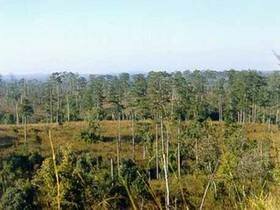
This is located at Km. 49 on Highway 12. From Km. 49 follow a track for about 5 Km. to the viewpoint. This area has pine forest and grassland areas. There is a nature trial that you can walk within this area.
Suan Son Phu Goom Kow View Point
From Km.53 on Highway 12. There is a track from this point that leads to the view point. A distance of about 15 Km. This area of pine forest covers an area of about 10 km2. During the cold season this area changes colour from green to brown and the grass becomes green. Many beautiful plants and flowers grow within this area. Phu Goom Kow Hill is about 880 m. tall. If you were to stand on top of this hill you would be able to see Chulabhorn Reservoir.
Tad Pran Ba Waterfall
The entrance is near Nam Nao Sub District Office , at the milestone number 20 on Ban Hauy Sanaam Sai- Lom Sak Distrct state highway, then the laterite road will lead you to the waterfall. Tad Pran Ba is a medium size waterfall with its 20 meters height and 2 floors. The water originated from Khern Stream flows all year round. It's so called Pran Ba because that is the name of the person who first discovered it, and Tad is a local word means waterfall.
Tam Par Hong View Point
This is located at Km. 39 on Highway 12. From the road walk 300m. to the view point where you will be rewarded with a good view. Walk a further 200m. to a spot which is particularly good for watching the sunset.
Tam Yai Nam Nao Cave
At Km. 60 on Highway (Ban Huai Sa Nam Sai-Amphur Lom Kow-Ban Nong Chart) The cave is close to the Park Substation (named after the cave). From the substation is a 3Km. track to the cave.
The cave is Limestone reaching a height of 955m. There is water flowing within the cave and you will see stalagmites and stalactites. Be careful not to touch these as it will stop their growth.
|