|
|
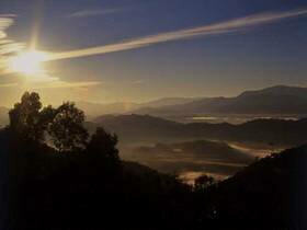
Mae Moei National Park has been surveyed and declared a national park since 1990, and belongs to National Park Division, Natural Resources Conservation Office, Royal Forest Department, Ministry of Agriculture and Cooperatives. It is named Mae Moei after Moei River which is the border between Thailand and Myanmar, and its west part is almost 50 kilometers stretching north and south. Moei River is a strange river; it goes from south to north. The park is about 185.28 squares kilometers, and in Mae U-su Sub-district, Maesong Sub-district, Thasongyang District, Tak Province. Most of the area is complicated mountains, approximately 680 meters above sea level (the highest peak is 1,250 meters above sea level), and has fewer plains. The area, covered by productive forest but the big trees are rarely found, is the main source of Song River, U-su River, Maesalid Luang River and Moei River. Chao Doi Waterfall Mae Salid Noi Waterfall Mae U-su Cave Mon Khrubasai Viewpoint Mon Kio Lom Viewpoint Sea of Fog View Point |