|
Lacated on Pung Huei Mountain range consist of Na Yang Gluk Conservation Forest and conservation preparing forest. Sai Thong National Park was designated on the 30th December 1992, with total area of 319 km2. The Park located in Amphur Nong Bua Rawae, Thep Satit, Pakdee Chumpon and Nong Bua Daeng, Chaiyaphum Province.
It is the head water of Lum Huai Prong Khun Pet, Lum Huai Chiang Ta, Lum Huai Yae, Lum Huai Yang, Lum Nam Jao-field of Shee River.
Chuan Chom Waterfall
located 2 km. above Sai Thong Waterfall, through peaceful nature trail.
Khao Pung Huai Viewpoint
located on Km. 70 of the highway 225 (Chaiyaphum-Nakornsawan). Lung Son Viewpoint: is the highest peak of Pung Huai Mountain range at 1,008 meters. above sea level. It has cool weather all year round. There are bungalows and campground provided.
Klong Sai Waterfall
recreation place located in Pakdee Chumpon District with small waterfall under peaceful forest.
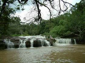
Sai Thong Waterfall
located in the Park Headquarters. There is a big pool, which you can swim on the top of the waterfall, called "Wang Ngueag", with water flow over the 150 m. long stone field.
Sightseeing
It is 1,008 meters high above the sea level. The weather is cool a whole year, besides there is an area for camping as well as an accommodation for any who wants to get in touch with the old weather.
Thung Bua Sawan
there is pinks and whites colour flower field on the west of Pung Huai Mountain. Yearly, from June to August, we can see bloomed curcuma flower over the field. Ecotourism study tour of which hiking and camping on the field is available.
|