|
|
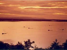
It is named Nam Phong National Park after its source called Nam Phong River which flows to be kept in Ubonratana Dam (also named Nam Phong Dam in the past). It is a national park, in accordance with the suggestion of Khon Kaen Province, called in the past "Nam Phong - Phu Meng" because some of its parts are in Phu Meng Mountain Range. Nam Phong National Park, located in the west part of Khon Kaen Province and close to Ubonratana Dam, is in the National Forest Reserve such as Sok Tae Forest, Phu Meng Forest, Khok Luang Forest, 3RD Cluster Khok Luang Forest, Phuphadam Forest and Phuphadaeng Forest in Ubonratana District, Banfang District, Nongruea District, Manchakhiri District, and Khok Pho Chai District, Khon Kaen Province. And some areas are in Banthan District and Kangkhro District, Chaiyaphum Province. It is about 197 square kilometers. The Park generally consists of sandstone mountain range, located above sea level and similar to the most mountain ranges in North Eastern Thailand. The mountain range, lying from north to south along with Ubonratana Dam, is the source of main rivers, for examples, Phong River, Choen River and Chi River. Its north part is in Phuphankham Mountain Range, and its south part is in Phu Meng Mountain Range. In the west side of the Park is alternately steep mountains and erected cliffs, some of which are in contact with the reservoir below. And in the east part of the park is a vastly plain area at the foothill which is about 600 meters above sea level. Famue Daeng Cliffs Going on foot, not far from Nam Pong National Park Office, to the Road for Studying Nature, Kome Phone, Plarn Chard and Hin Chang Si, there are many cliffs along the road. From each of the cliffs, traveler can see the beautiful scenery of Ubonrat Dam, the condition of the forest and the west-side mountain range clearly. So that makes this be a suitably circle-walking trip for studying nature within 3-4 hours. Hin Chang Si View Point It is a group of rock, located in the ridge of Soktae Forest Mountain north of Nam Phong National Park Headquarters, which is the best view point of Nam Phong National Park for watching sunrise and sunset. It is named Hin Chang Si (Elephant-rubbing Rock) because, in the past, there had wild elephants come to rub their body against the rock and left the soil on it. On the Hin Chang Si View Point lays a large floor of rock. And at the top of it is a skull-like rock located solely. Traveler on the floor can explore all surrounding sceneries, for example, in the north and south are covered with evergreen forest, very far away is Khon Kaen City, and in the west is the wonderful scenery of Ubonratana Reservoir which is not only beautiful but also very large and vastly far away until out of sigh at Phuwiang and Phukao Mountain Range. Kham Phon Pha Sawan Phalan Chat or Lan Chat Phumeng Mountain Ubonratana Reservoir
|
|||||||||||||||||||||||||||||||||||||||||||||||||||||||