Na Yung Nam Som National Park
|
Na Yung Nam Som National Park Located some 100 kilometers northwest of the provincial capital, beyond Phu Phar Bat Historical Park, in Amphoe Nam Som, this park is best known for the 40-metre high Yung Thong Waterfall which cascades down a steep cliff in verdant surrounding from the Phu-Pan and Phu Ya U ridges.
Na Yung-Nam Som National Park is the 3 patched-province area: Udonthani, Loei and Nongkhai, The topography condition is slope complex mountainous above 200-500 m from msl, the mountain with the highest peak is Phu Ya-u about 588 m. General forest condition is still maintain the abundance where it is the main source of the river and the stream, such as Huai Nam Som, Huai Tat Ton.
Namtok Yung Thong Nature Trail
Nature trail of Namtok Yung Thong is a on-foot trail for studying the nature of National Park. Interpretation method use description along the interval nature trail pass Namtok Yung Thong Namtok Tat Noi, Pha Daeng scenery point with beautiful Dry dipterocarp forest, back to National park office with total area 2,000 m.
Pha Daeng Scenery Viewpoint
Pha Daeng Scenery viewpoint far from National park office about 1,500 m. Fallow the Namtok Yung Thong sand stone slope cliff nature trail can see a large beautiful scenery down.
Than Thip Waterfall
Namtok Than Thip (or Namtok Tat Mok) is a waterfall in the boundary of Nongkhai Province close Khong river.
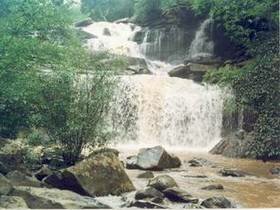
Yung Thong Waterfall
Namtok Yung Thong far from National Park office about 500 m. Very beautiful in rainy season, flow from height slope cliff about 25 m. There is a large pound can play water. The past time it used to be a earned living and sanctuary of Green Peafowl (Nok Yung in Thai) and became the name of Yung Thong. Nowadays Green Peafowl was hunted and extinct.
|